

Draw a line from Wilson to Nanyuki, or Wilson to Nyeri, or Wilson to almost anywhere in the central highlands. Somewhere on that line sits the Aberdare Range, and most students barely register it beyond a green smudge on the chart.
That is exactly the problem. A 160 km ridge that climbs to nearly 4,000 metres is not a smudge, it is the single biggest terrain feature between Nairobi and half the destinations a Kenyan student pilot will ever fly to.
The Short Version
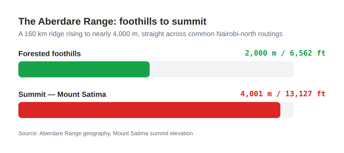
- The Aberdare Range runs roughly 160 km north of Nairobi, climbing from forested foothills around 2,000 m to Mount Satima's summit at 4,001 m (13,127 ft).
- Mountain wave and rotor turbulence form on the lee side of ranges like this, and internationally recognised guidance rates rotor turbulence as comparable to, or worse than, what research pilots have found inside thunderstorms.
- On 5 June 2018, Fly-SAX Flight 102, a Cessna 208B Grand Caravan on a Kitale to Jomo Kenyatta International Airport run, struck Elephant Hill in the Aberdares. All 10 people on board died.
- The investigation found the crew flying IFR below the minimum altitude for the region, on a route they were not fully familiar with, in deteriorating weather.
- You do not need to be flying IFR for the same mechanism to catch you. A VFR pilot who lets weather close in near rising terrain is exposed to the identical outcome.
The range you fly past without really seeing
The Aberdares straddle Nyandarua, Nyeri, Murang'a, Kiambu and Laikipia counties, an average elevation of around 3,500 m across the whole range (Britannica, Aberdare Range).
Mount Satima, the highest point, tops out at 4,001 m, or 13,127 feet. The forested foothills start much lower, around 2,000 m, which means the range gains almost 2,000 m of relief in a relatively short horizontal distance.
That steep rise matters more than the raw altitude number. A C172 cruising comfortably at 8,500 ft over the Rift Valley floor is nowhere near clear of terrain once that same routing bends toward the Aberdares.
Nyeri and Mweiga airstrips sit close to the range's eastern flank, and Nanyuki lies not far beyond its northern end. Any student flying a cross-country toward those fields, or toward Nyahururu, is planning a route that has to respect this terrain, not just glance at it on a sectional.
What a mountain wave actually does to your aircraft
Wind blowing across a mountain range does not just get bumpy near the ridge. It sets up a wave pattern that can extend for tens of miles downwind, and underneath that wave, where the wave motion meets surface friction, rotor turbulence can form.
SkyBrary's summary of mountain wave hazards, drawing on the World Meteorological Organization's guidance on the subject, makes a point worth sitting with: turbulence inside a mountain wave rotor can exceed what research pilots have measured flying deliberately into thunderstorms.
The FAA takes the same hazard seriously enough to have written a dedicated advisory circular on it, AC 00-57, Hazardous Mountain Winds. Strong vertical currents combined with surface friction beneath the wave are what generate the rotor, and rotor turbulence is exactly the kind of hazard that does not show up as a smooth ride until it suddenly does.
None of this requires a Kenya-specific study to matter here. Wind meeting an 1,500 to 2,000 m wall of terrain behaves the same way whether that wall is in Colorado or Nyandarua County.
Elephant Hill, 2018: what the investigation actually found
This is the part that deserves care, not drama. On 5 June 2018, a Cessna 208B Grand Caravan operating as Fly-SAX Flight 102 was flying from Kitale to Jomo Kenyatta International Airport when it struck Elephant Hill, a peak within the Aberdare Range.
All 10 people on board were killed. The investigation into the accident found the crew were flying under instrument flight rules at an altitude below the minimum safe altitude for that region (The Standard, on the aviation authority's findings).
Kenyan press coverage of the investigation's conclusions reported that the crew were not fully familiar with the Kitale to JKIA routing, and that questions were raised about their preparation and communication before the flight (Tuko.co.ke; Nairobi News).
One detail from the coverage is worth flagging on its own. The aircraft carried neither a flight data recorder nor a cockpit voice recorder, and neither was required by Kenyan regulation for that aircraft category at the time, which made reconstructing the final minutes harder for investigators than it needed to be.
The accident is a textbook description of controlled flight into terrain: a functioning aircraft, flown by a crew, into high ground, in conditions where the terrain was not seen in time. That is precisely the failure mode this article exists to help you avoid.
Why this matters even if you never file IFR
It would be easy to read the Fly-SAX case and file it under "IFR problem, not mine." That reading misses the actual lesson.
Controlled flight into terrain does not care what flight rules you are operating under. It cares about three things: how close you are to rising ground, how much you can actually see of it, and how much margin you have built into your altitude before you needed it.
A VFR student who presses a cross-country toward Nyeri as cloud base drops near the Aberdares is exposed to the same physics as an IFR crew below minimum safe altitude. The instrument rating is not what keeps you separated from a hillside, awareness and margin are.
The opinion part
Here is where I will say the thing most syllabi dance around. Terrain awareness in Kenyan training gets folded into "weather decision-making" as if it is the same subject, and it is not.
Weather tells you whether to go. Terrain tells you where you are allowed to be wrong about the weather and still survive the mistake, and near the Aberdares that margin for error is thinner than most students realise until someone shows them the numbers.
A CFI (Certified Flight Instructor) who runs a Nairobi-north cross-country briefing without naming the Aberdares specifically, by height, by hazard, and by the Elephant Hill case, is leaving out the single most consequential fact of that flight.
How this differs from the Rift Valley
It is worth being precise about this, because the two hazards get lumped together in casual conversation and they are not the same thing. Rift Valley turbulence is mostly thermal and mechanical, driven by the escarpment heating unevenly through the day and by wind funnelling along the valley floor.
The Aberdares hazard is different in kind. A mountain wave forms when wind flows across a substantial ridge and sets up an oscillating pattern downwind, with rotor turbulence forming beneath it where that wave motion meets surface friction, and it can be just as active on a cold, clear morning as on a hot afternoon.
The practical upshot is that "it's early, the thermals haven't built yet" is not a reason to relax near the Aberdares the way it might be over the Rift Valley floor. Wind direction and speed relative to the ridge line are what matter here, not time of day.
Route and altitude planning that actually respects the terrain
None of this needs to be complicated. It needs to be deliberate, every time the route crosses or skirts the range.
- Know the highest terrain on your route, not the average. Plan against Mount Satima's 4,001 m where the route passes near the range's spine, not against the lower foothill figure that happens to sit under your departure point.
- Build in a real margin, and brief it out loud. A cruising altitude that clears the highest terrain on your route by a comfortable margin, decided before takeoff, is worth more than any in-flight judgement call made under time pressure.
- Treat closing cloud base near the range as a turn-back trigger, not a wait-and-see. The moment you are choosing between descending toward terrain you cannot fully see and turning around, the decision should already have been made in the briefing room.
- Expect turbulence on the lee side, especially in stronger wind. A wave or rotor encounter near the Aberdares is not a sign you did something wrong, it is a sign the terrain and wind are interacting exactly as they are expected to.
- File and update your flight plan for any route that touches the range. If something does go wrong near high ground, search and rescue starting from a known route and timing is the difference that matters most.
Frequently asked questions
How high is the Aberdare Range?
The range rises from forested foothills around 2,000 m to Mount Satima's summit at 4,001 m (13,127 ft), across an average elevation of roughly 3,500 m along its 160 km length.
What caused the 2018 Fly-SAX accident in the Aberdares?
The investigation found the crew were flying IFR below the minimum safe altitude for the region, on a route they were not fully familiar with, and the aircraft struck Elephant Hill. All 10 people on board were killed.
Is mountain wave turbulence only a risk for aircraft flying close to the terrain?
No. Mountain wave effects can extend well downwind of the range that generates them, and rotor turbulence beneath the wave can be severe even away from the immediate ridge line.
Does this only apply to IFR flights?
No. Controlled flight into terrain is a function of proximity to rising ground, visibility, and altitude margin, all of which apply equally to a VFR flight that lets weather close in near high terrain.
Key Takeaways
- The Aberdare Range runs roughly 160 km north of Nairobi and rises to 4,001 m at Mount Satima, a major terrain feature on many routine cross-country routes.
- Mountain wave and rotor turbulence on the lee side of a range this size can be severe, comparable to what research pilots have recorded inside thunderstorms.
- The 2018 Fly-SAX Flight 102 accident, a CFIT into Elephant Hill that killed all 10 on board, is a documented case study in what happens when altitude margin and terrain awareness fail together.
- The lesson applies to VFR flights just as much as IFR ones. Closing weather near rising terrain is the hazard, not the flight rules you happen to be operating under.
- Plan against the highest terrain on the route, brief a real altitude margin before takeoff, and treat a dropping cloud base near the range as a turn-back trigger decided in advance.